Saturday, November 22, 2008

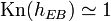
The topographic map illustrated in Figure 10l-1 suggests that the Earth's surface has been deformed. This deformation is the result of forces that are strong enough to move ocean sediments to an eleveation many thousands meters above sea level. In previous lectures, we have discovered that this displacement of rock can be caused by tectonic plate movement and subduction, volcanic activity, and intrusive igneous activity.

Figure 10l-1: Topographic relief of the Earth's terrestrial surface and ocean basins. Ocean trenches and the ocean floor have the lowest elevations on the image and are colored dark blue. Elevation is indicated by color. The legend below shows the relationship between color and elevation. (Source: National Geophysical Data Center, National Oceanic and Atmospheric Administration).

Deformation of rock involves changes in the shape and/or volume of these substances. Changes in shape and volume occur when stress and strain causes rock to buckle and fracture or crumple into folds. A fold can be defined as a bend in rock that is the response to compressional forces. Folds are most visible in rocks that contain layering. For plastic deformation of rock to occur a number of conditions must be met, including:

  • The rock material must have the ability to deform under pressure and heat.
  • The higher the temperature of the rock the more plastic it becomes.
  • Pressure must not exceed the internal strength of the rock. If it does, fracturing occurs.
  • Deformation must be applied slowly.

A number of different folds have been recognized and classified by geologists. The simplest type of fold is called a monocline (Figure 10i-2). This fold involves a slight bend in otherwise parallel layers of rock.

Figure 10l-2: Monocline fold.

An anticline is a convex up fold in rock that resembles an arch like structure with the rock beds (or limbs) dipping way from the center of the structure (Figure 10l-3).

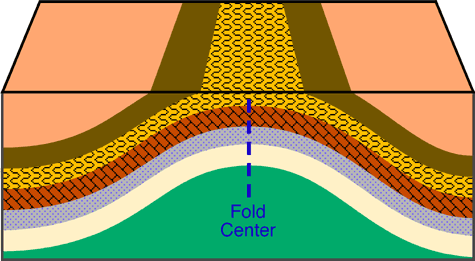
Figure 10l-3: Anticline fold. Note how the rock layers dip away from the center of the fold are roughly symmetrical.

A syncline is a fold where the rock layers are warped downward (Figure 10l-4 and 10l-5). Both anticlines and synclines are the result of compressional stress.

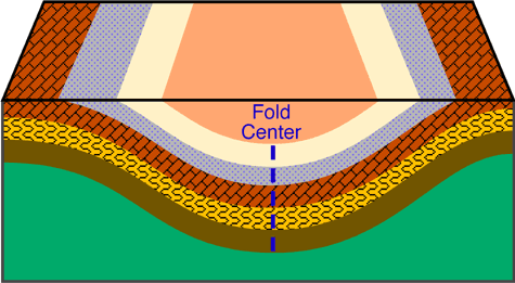
Figure 10l-4: Syncline fold. Note how the rock layers dip toward the center of the fold and are roughly symmetrical.

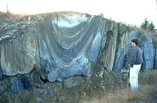
Figure 10l-5: Synclinal folds in bedrock, near Saint-Godard-de-Lejeune, Canada. (Source: Natural Resources Canada - Terrain Sciences Division - Canadian Landscapes).

More complex fold types can develop in situations where lateral pressures become greater. The greater pressure results in anticlines and synclines that are inclined and asymmetrical (Figure 10l-6).

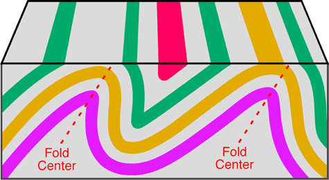
Figure 10l-6: The following illustration shows two anticline folds which are inclined. Also note how the beds on either side of the fold center are asymmetrical.

A recumbent fold develops if the center of the fold moves from being once vertical to a horizontal position (Figure 10l-7). Recumbent folds are commonly found in the core of mountain ranges and indicate that compression and/or shear forces were stronger in one direction. Extreme stress and pressure can sometimes cause the rocks to shear along a plane of weakness creating a fault. We call the combination of a fault and a fold in a rock an overthrust fault.

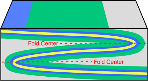
Figure 10l-7: Recumbent fold.

Faults form in rocks when the stresses overcome the internal strength of the rock resulting in a fracture. A fault can be defined as the displacement of once connected blocks of rock along a fault plane. This can occur in any direction with the blocks moving away from each other. Faults occur from both tensional and compressional forces. Figure 10l-8 shows the location of some of the major faults located on the Earth.

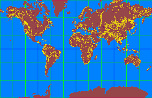
Figure 10l-8: Location of some of the major faults on the Earth. Note that many of these faults are in mountainous regions (see section 10k).

There are several different kinds of faults. These faults are named according to the type of stress that acts on the rock and by the nature of the movement of the rock blocks either side of the fault plane. Normal faults occur when tensional forces act in opposite directions and cause one slab of the rock to be displaced up and the other slab down (Figure 10l-9).

Figure 10l-9: Animation of a normal fault.

Reverse faults develop when compressional forces exist (Figure 10l-10). Compression causes one block to be pushed up and over the other block.

Figure 10l-10: Animation of a reverse fault.

A graben fault is produced when tensional stresses result in the subsidence of a block of rock. On a large scale these features are known as Rift Valleys (Figure 10l-11).

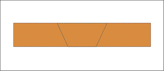
Figure 10l-11: Animation of a graben fault.

A horst fault is the development of two reverse faults causing a block of rock to be pushed up (Figure 10l-12).

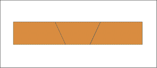
Figure 10l-12: Animation of a horst fault.

The final major type of fault is the strike-slip or transform fault. These faults are vertical in nature and are produced where the stresses are exerted parallel to each other (Figure 10l-13). A well-known example of this type of fault is the San Andreas fault in California.


Figure 10l-13: Transcurrent fault zones on and off the West coast of North America. (Source: U.S. Geological Survey).
Latitude, usually denoted symbolically by the Greek letter phi (Φ) gives the location of a place on Earth (or other planetary body) north or south of the equator. Lines of Latitude are the horizontal lines shown running east-to-west on maps. Technically, latitude is an angular measurement in degrees (marked with °) ranging from 0° at the equator (low latitude) to 90° at the poles (90° N for the North Pole or 90° S for the South Pole; high latitude). The complementary angle of a latitude is called the colatitude.

Magma (Plurals include: magmas and magmata) is molten rock that sometimes forms beneath the surface of the earth (or any other terrestrial planet) that often collects in a magma chamber inside a volcano. Magma may contain suspended crystals and gas bubbles. By definition, all igneous rock is formed from magma.

Hawaiian lava flow (lava is the extrusive equivalent of magma *Pahoehoe)

Magma is a complex high-temperature fluid substance. Temperatures of most magmas are in the range 700 °C to 1300 °C (or 1292 °F to 2372 °F), but very rare carbonatite melts may be as cool as 600 °C, and komatiite melts may have been as hot at 1600 °C. Most are silicate solutions.

Magma is capable of intrusion into adjacent rocks, extrusion onto the surface as lava, and explosive ejection as tephra to form pyroclastic rock.

Environments of magma formation and compositions are commonly correlated. Environments include subduction zones, continental rift zones, mid-oceanic ridges, and hotspots, some of which are interpreted as mantle plumes. Environments are discussed in the entry on igneous rock. Magma compositions may evolve after formation by fractional crystallization, contamination, and magma mixing.

Contrary to some impressions,[clarify] the bulk of the Earth's crust and mantle is not molten. Rather, the bulk of the Earth takes the form of a rheid, a form of solid that can move or deform under pressure. Magma, as liquid, preferentally forms in high temperature, low pressure environments within several kilometers of the Earth's surface.

An earthquake or seism is the result of a sudden release of energy in the Earth's crust that creates seismic waves. Earthquakes are recorded with a seismometer, also known as a seismograph. The moment magnitude of an earthquake is conventionally reported, or the related and mostly obsolete Richter magnitude, with magnitude 3 or lower earthquakes being mostly imperceptible and magnitude 7 causing serious damage over large areas. Intensity of shaking is measured on the modified Mercalli scale.

At the Earth's surface, earthquakes manifest themselves by shaking and sometimes displacing the ground. When a large earthquake epicenter is located offshore, the seabed sometimes suffers sufficient displacement to cause a tsunami. The shaking in earthquakes can also trigger landslides and occasionally volcanic activity.

In its most generic sense, the word earthquake is used to describe any seismic event—whether a natural phenomenon or an event caused by humans—that generates seismic waves. Earthquakes are caused mostly by rupture of geological faults, but also by volcanic activity, landslides, mine blasts, and nuclear experiments. An earthquake's point of initial rupture is called its focus or hypocenter. The term epicenter refers to the point at ground level directly above this.

Saturday, November 15, 2008

TRANSFORMATIONAL

A good example of this type of motion is the San Andreas Fault which runs through California.

CONVERGENT

This is the most common kind of motion at subduction zones. This motion happens where dense oceanic plates colide and slide beneath continental plates.

DIVERGENT

This is the most common kind of motion along the mid-ocean ridges. This is a system of undersea mountain ranges that extends beneath the world's oceans and connects together like the seams on a baseball.

Plates? What Plates?

12 05 2008

Plate tectonics is one of those topics that you generally skim through in junior high. But what exactly are plates and how are they related to earthquakes? Plate tectonics is a theory that has become a well-accepted reason to explain geological facts about Earth.

The basic idea of plate tectonics is that the Earth is made up of several large, moving pieces of solid rock, on the ocean and on continents. They are plates floating on softer like rock. The plates are in constant motion and sometimes run into one another, this is called a collision, or they slide along, over or under one another. Their motion, and collisions can explain several geological events including earthquakes. It also explains the presence of faults on many continents, where two plates collide, including the San Andreas fault in California.

Under the ocean, the plates explain why there is major seismic energy in the Pacific Ocean and how deep ocean trenches and large fracture zones and rifts in the ocean floor occur. Plates also give reason to associate volcanoes and large mountain belts like the Andes. Plates are the reason mountain belts form, from the pushing of plates and vast spreading and colliding of plate tectonics..

Why are plates so important to understand? How do they contribute to our overall understanding of Earth and seismic motion?

Here is a great article about Plate Tectonics with great illustrations and explanations about faults, environments and locations of plates on Earth. Check it out!

T
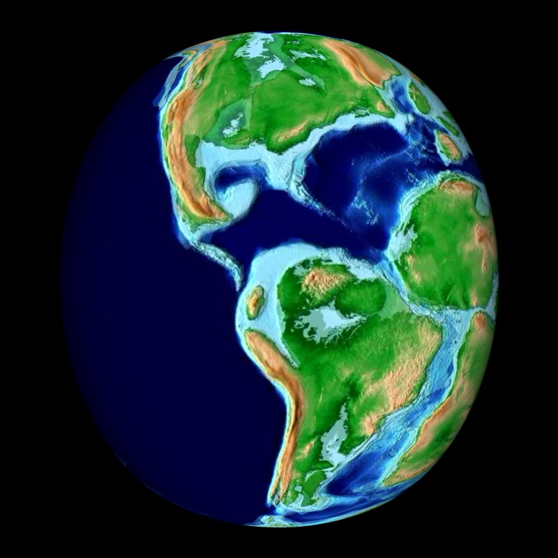
he Pangaea Theory asserts that all of the plates were connected at one point and slowly shifted away from one another. This large continent is called Pangaea. Take the online quiz to test and learn more about this excited theory related to plate tectonics!

PANGAEA

Pangaea

During the last decades the capability and precision of tools used to sample and analyze our earth have increased exponentially - with an analogous increase in the resulting data output. At the same time, the information technology has made significant advances, which allow storage, distribution and processing of a nearly unlimited amount of data. Not concurrent with this progress is, however, the development of a related culture for a sustainable delivery of scientific data to future research. It is no longer feasible to publish data in publications. In spite of this, the bibliographic archiving of primary data from projects and publications is still not an integral part of the scientific workflow and thus most of the data are getting lost while hardware and software are changing quickly. Today this is considered to be one of the most crucial deficiencies in science. Various institutions, foundations and international organizations like the OECD are currently formulating recommendations for an improved data archiving.

Thanks to the support of AWI’s computer centre, scientists at AWI and MARUM after many years of work were able to build a sustainable information system. PANGAEA®, as a universal data library, is also a publication system and allows integration of data in the established process of scientific publications. Thus Pangaea is an information system, which encourages scientists to freely archive their data in an open access environment.

Ozone
Through a well-defined editorial workflow, the archived data are related to any information required for its understanding being citable and accessible in formats following international standards. The universality of the system allows the storage of any parameter from the upper atmosphere down into the deep earth crust, covering the wide range of disciplines in natural sciences. Extraction of individual subsets from the inventory is enabled through a data warehouse, which, as part of the PANGAEA® system, provides the framework for solving new scientific questions related to our earth.

Monday, November 10, 2008

The thermosphere is the layer of the earth's atmosphere directly above the mesosphere and directly below the exosphere. Within this layer, ultraviolet radiation causes ionization.

The thermosphere, named from the Greek θερμός (thermos) for heat, begins about 90 km above the earth.[1] At these high altitudes, the residual atmospheric gases sort into strata according to molecular mass (see turbosphere). Thermospheric temperatures increase with altitude due to absorption of highly energetic solar radiation by the small amount of residual oxygen still present. Temperatures are highly dependent on solar activity, and can rise to 1,500°C. Radiation causes the atmosphere particles in this layer to become electrically charged (see ionosphere), enabling radio waves to bounce off and be received beyond the horizon. At the exosphere, beginning at 500 to 2,000 km above the earth's surface, the atmosphere mixes into space.

The few particles of gas in this area can reach 2,500°C (4532°F) during the day. Even though the temperature is so high, one would not feel warm in the thermosphere, because it is so near vacuum that there is not enough contact with the few atoms of gas to transfer much heat. A normal thermometer would read significantly below 0°C.

The upper region of this atmospheric layer is called the ionosphere.

The dynamics of the lower thermosphere (below about 120 km) are dominated by atmospheric tide, which is driven, in part, by the very significant diurnal heating. The atmospheric tide dissipates above this level since molecular concentrations do not support the coherent motion needed for fluid flow.

The International Space Station has a stable orbit within the upper part of the thermosphere, between 320 and 380 kilometers. The auroras also occur in the thermosphere.

The exosphere is the uppermost layer of the atmosphere. On Earth, its lower boundary at the edge of the thermosphere is estimated to be 500 km to 1000 km above the Earth's surface, and its upper boundary at about 10,000 km. It is only from the exosphere that atmospheric gases, atoms, and molecules can, to any appreciable extent, escape into space. The main gases within the exosphere are the lightest gases, mainly hydrogen, with some helium, carbon dioxide, and atomic oxygen near the exobase. The exosphere is the last layer before space.

Exobase, also called the critical level, the lowest altitude of the exosphere, is defined in one of two ways:

  1. The height above which there are the negligible atomic collisions between the particles and
  2. The height above which constituent atoms are on purely ballistic trajectories.
At the exobase, the mean free path of a molecule is equal to one pressure scale height. As the pressure scale height is almost equal to the density scale height of the primary constituent, and since the Knudsen number is the ratio of mean free path and typical density fluctuation scale, this means that the exobase lies in the region where \mathrm{Kn}(h_{EB}) \simeq 1

The mesosphere (from the Greek words mesos = middle and sphaira = ball) is the layer of the Earth's atmosphere that is directly above the stratosphere and directly below the thermosphere. The mesosphere is located from about 50 km to 80-90 km altitude above Earth's surface. Within this layer, temperature decreases with increasing altitude due to decreasing solar heating and increasing cooling by CO2 radiative emission. The minimum in temperature at the top of the mesosphere is called the mesopause, and is the coldest place in the atmosphere. [1] The main dynamical features in this region are atmospheric tides, internal atmospheric gravity waves (usually just called "gravity waves") and planetary waves. Most of these waves and tides are excited in the troposphere and lower stratosphere and propagate upward to the mesosphere. In the mesosphere, gravity-wave amplitudes can become so large that the waves become unstable and dissipate. This dissipation deposits momentum into the mesosphere and largely drives its global circulation.

Atmosphere diagram showing the mesosphere and other layers. The layers are not to scale.

Because it lies between the maximum altitude for aircraft and the minimum altitude for orbital spacecraft, this region of the atmosphere has only been accessed through the use of sounding rockets. As a result, it is the most poorly understood part of the atmosphere. This has led the mesosphere and the lowest thermosphere to be disparagingly referred to by scientists as the ignorosphere [1] [2].

Temperatures in the upper mesosphere fall as low as -100°C (-146°F or 173 K) [3], varying according to latitude and season. Millions of meteors burn up daily in the mesosphere as a result of collisions with the gas particles contained there; this creates enough heat to vaporize almost all of the falling objects long before they reach the ground, resulting in a high concentration of iron and other metal atoms there.

The stratosphere and mesosphere are referred to as the middle atmosphere. The mesopause, at an altitude of 80-90 km, separates the mesosphere from the thermosphere—the second-outermost layer of the Earth's atmosphere. This is also around the same altitude as the turbopause, below which different chemical species are well mixed due to turbulent eddies. Above this level the atmosphere becomes non-uniform; the scale heights of different chemical species differ by their molecular weights.

Noctilucent clouds are located in the mesosphere.

The Mesosphere is also the region of the Ionosphere known as the D Layer. The D Layer is only present during the day, when some ionization occurs with nitric oxide being ionized by Lyman series-alpha hydrogen radiation. The ionization is so weak that when night falls, and the source of ionization is removed, the free electron and ion form back into a nuetral molecule.

Troposphere

The lowest layer of the atmosphere is called the troposphere. It ranges in thickness from 8km at the poles to 16km over the equator. The troposphere is bounded above by the tropopause, a boundary marked by stable temperatures. Above the troposphere is the stratosphere. Although variations do occur, temperature usually declines with increasing altitude in the troposphere. Hill walkers know that it will be several degrees cooler on the top of a mountain than in the valley below.

The troposphere is denser than the layers of the atmosphere above it (because of the weight compressing it), and it contains up to 75% of the mass of the atmosphere. It is primarily composed of nitrogen (78%) and oxygen (21%) with only small concentrations of other trace gases. Nearly all atmospheric water vapour or moisture is found in the troposphere.

The troposphere is the layer where most of the world's weather takes place. Since temperature decreases with altitude in the troposphere, warm air near the surface of the Earth can readily rise, being less dense than the colder air above it. In fact air molecules can travel to the top of the troposphere and back down again in a just a few days. Such vertical movement or convection of air generates clouds and ultimately rain from the moisture within the air, and gives rise to much of the weather which we experience. The troposphere is capped by the tropopause, a region of stable temperature. Air temperature then begins to rise in the stratosphere. Such a temperature increase prevents much air convection beyond the tropopause, and consequently most weather phenomena, including towering cumulonimbus thunderclouds, are confined to the troposphere.

Sometimes the temperature does not decrease with height in the troposphere, but increases. Such a situation is known as a temperature inversion. Temperature inversions limit or prevent the vertical mixing of air. Such atmospheric stability can lead to air pollution episodes with air pollutants emitted at ground level becoming trapped underneath the temperature inversion.

The stratosphere is the second major layer of Earth's atmosphere, just above the troposphere, and below the mesosphere. It is stratified in temperature, with warmer layers higher up and cooler layers farther down. This is in contrast to the troposphere near the Earth's surface, which is cooler higher up and warmer farther down. The border of the troposphere and stratosphere, the tropopause, is marked by where this inversion begins, which in terms of atmospheric thermodynamics is the equilibrium level. The stratosphere is situated between about 10 km (6 miles) and 50 km (31 miles) altitude above the surface at moderate latitudes, while at the poles it starts at about 8 km (5 miles) altitude.

The stratosphere is layered in temperature because it is heated from above by absorption of ultraviolet radiation from the Sun. Within this layer, temperature increases as altitude increases (see temperature inversion); the top of the stratosphere has a temperature of about 270 K (−3°C or 26.6°F), just slightly below the freezing point of water.[1] This top is called the stratopause, above which temperature again decreases with height. The vertical stratification, with warmer layers above and cooler layers below, makes the stratosphere dynamically stable: there is no regular convection and associated turbulence in this part of the atmosphere. The heating is caused by an ozone layer that absorbs solar ultraviolet radiation, heating the upper layers of the stratosphere. The base of the stratosphere occurs where heating by conduction from above and heating by convection from below (through the troposphere) balance out; hence, the stratosphere begins at lower altitudes near the poles due to the lower ground temperature there.

Commercial airliners typically cruise at an altitude near 10 km in temperate latitudes, in the lower reaches of the stratosphere.[citation needed] They do this to optimize jet engine fuel burn, mostly thanks to the low temperatures encountered near the tropopause. It also allows them to stay above any hard weather, and avoid atmospheric turbulence from the convection in the troposphere. Turbulence experienced in the cruise phase of flight is often caused by convective overshoot from the troposphere below. Similarly, most gliders soar on thermal plumes that rise through the troposphere above warm patches of ground; these plumes end at the base of the stratosphere, setting a limit to how high gliders can fly in most parts of the world. (Some gliders do fly higher, using ridge lift from mountain ranges to lift them into the stratosphere.)

The stratosphere is a region of intense interactions among radiative, dynamical, and chemical processes, in which horizontal mixing of gaseous components proceeds much more rapidly than vertical mixing. An interesting feature of stratospheric circulation is the quasi-Biennial Oscillation (QBO) in the tropical latitudes, which is driven by gravity waves that are convectively generated in the troposphere. The QBO induces a secondary circulation that is important for the global stratospheric transport of tracers such as ozone or water vapor.

In northern hemispheric winter, sudden stratospheric warmings can often be observed which are caused by the absorption of Rossby waves in the stratosphere.

ATMOSPHERE

The Earth's atmosphere is a layer of gases surrounding the planet Earth that is retained by the Earth's gravity. Dry air contains roughly (by molar content – equivalent to volume, for gases) 78.08% nitrogen, 20.95% oxygen, 0.93% argon, 0.038% carbon dioxide, and trace amounts of other gases; but air also contains a variable amount of water vapor, on average around 1%. This mixture of gases is commonly known as air. The atmosphere protects life on Earth by absorbing ultraviolet solar radiation and reducing temperature extremes between day and night.

There is no definite boundary between the atmosphere and outer space. It slowly becomes thinner and fades into space. Three quarters of the atmosphere's mass is within 11 km of the planetary surface. An altitude of 120 km (~75 miles or 400,000 ft) marks the boundary where atmospheric effects become noticeable during re-entry. The Kármán line, at 100 km (62 miles or 328,000 ft), is also frequently regarded as the boundary between atmosphere and outer space.

LITHOSPHERE

The lithosphere (geosphere) is the "solid" part of Earth. It has two parts, the crust and the upper mantle.

The crust is Earth's outermost layer. The crust varies from 5 to 70 kilometers in thickness. The crust includes rocks, minerals, and soil. There are two kinds of crust: continental and oceanic. Yes, there is even crust under the ocean!

The crust is constantly moving, which is why continents move and earthquakes happen. The science that studies how the parts of the crust move is called "Plate Tectonics."

Earth's oceanic crust is a thin layer of dense rock about 5 kilometers thick. The continental crust is less
dense,with lighter-colored rock, that varies from 30 to 70 kilometers thick. The continental crust is older
and thicker than the oceanic crust.


The crust is made of many types of rocks and hundreds of minerals. These rocks and minerals are made from just 8 elements:
Oxygen (46.6%), Silicon (27.72%), Aluminum (8.13%), Iron (5.00%), Calcium (3.63%), Sodium (2.83%), Potassium (2.70%), and Magnesium (2.09%). The oceanic crust has more Silicon, Oxygen, and Magnesium. The continental crust has more Silicon and Aluminum.

Tuesday, November 4, 2008

Fossil fuel

From Wikipedia, the free encyclopedia

Jump to: navigation, search
Coal, one of the fossil fuels.

Fossil fuels or mineral fuels are fossil source fuels, that is, hydrocarbons found within the top layer of the Earth’s crust.

Fossil fuels range from volatile materials with low carbon:hydrogen ratios like methane, to liquid petroleum to nonvolatile materials composed of almost pure carbon, like anthracite coal. Methane can be found in hydrocarbon fields, alone, associated with oil, or in the form of methane clathrates. It is generally accepted that they formed from the fossilized remains of dead plants and animals[1] by exposure to heat and pressure in the Earth's crust over hundreds of millions of years.[2] This biogenic theory was first introduced by Georg Agricola in 1556 and later by Mikhail Lomonosov in 1757.

It was estimated by the Energy Information Administration that in 2005, 86% of primary energy production in the world came from burning fossil fuels, with the remaining non-fossil sources being hydroelectric 6.3%, nuclear 6.0%, and other (geothermal, solar, wind, and wood and waste) 0.9 percent.[3]

Fossil fuels are non-renewable resources because they take millions of years to form, and reserves are being depleted much faster than new ones are being formed. Concern about fossil fuel supplies is one of the causes of regional and global conflicts. The production and use of fossil fuels raise environmental concerns. A global movement toward the generation of renewable energy is therefore under way to help meet increased energy needs.

The burning of fossil fuels produces around 21.3 billion tones (21.3 gigatons) of carbon dioxide per year, but it is estimated that natural processes can only absorb about half of that amount, so there is a net increase of 10.65 billion tones of atmospheric carbon dioxide per year (one tonne of atmospheric carbon is equivalent to 44/12 or 3.7 tones of carbon dioxide).[4] Carbon dioxide is one of the greenhouse gases that enhances radiative forcing and contributes to global warming, causing the average surface temperature of the Earth to rise in response, which climate scientists agree will cause major adverse effects, including reduced biodiversity.

Mechanical Energy as the Ability to Do Work

An object which possesses mechanical energy is able to do work. In fact, mechanical energy is often defined as the ability to do work. Any object which possesses mechanical energy - whether it be in the form of potential energy or kinetic energy - is able to do work. That is, its mechanical energy enables that object to apply a force to another object in order to cause it to be displaced.

Numerous examples can be given of how an object with mechanical energy can harness that energy in order to apply a force to cause another object to be displaced. A classic example involves the massive wrecking ball of a demolition machine. The wrecking ball is a massive object which is swung backwards to a high position and allowed to swing forward into building structure or other object in order to demolish it. Upon hitting the structure, the wrecking ball applies a force to it in order to cause the wall of the structure to be displaced. The diagram below depicts the process by which the mechanical energy of a wrecking ball can be used to do work.

A hammer is a tool which utilizes mechanical energy to do work. The mechanical energy of a hammer gives the hammer its ability to apply a force to a nail in order to cause it to be displaced. Because the hammer has mechanical energy (in the form of kinetic energy), it is able to do work on the nail. Mechanical energy is the ability to do work.

Another example which illustrates how mechanical energy is the ability of an object to do work can be seen any evening at your local bowling alley. The mechanical energy of a bowling ball gives the ball the ability to apply a force to a bowling pin in order to cause it to be displaced. Because the massive ball has mechanical energy (in the form of kinetic energy), it is able to do work on the pin. Mechanical energy is the ability to do work.

A dart gun is still another example of how mechanical energy of an object can do work on another object. When a dart gun is loaded and the springs are compressed, it possesses mechanical energy. The mechanical energy of the compressed springs give the springs the ability to apply a force to the dart in order to cause it to be displaced. Because of the springs have mechanical energy (in the form of elastic potential energy), it is able to do work on the dart. Mechanical energy is the ability to do work.

A common scene in some parts of the countryside is a "wind farm." High speed winds are used to do work on the blades of a turbine at the so-called wind farm. The mechanical energy of the moving air give the air particles the ability to apply a force and cause a displacement of the blades. As the blades spin, their energy is subsequently converted into electrical energy (a non-mechanical form of energy) and supplied to homes and industries in order to run electrical appliances. Because the moving wind has mechanical energy (in the form of kinetic energy), it is able to do work on the blades. Once more, mechanical energy is the ability to do work.


Fission Diagram


Nuclear EnergyNuclear Energy

The sun and stars are seemingly inexhaustible sources of energy. That energy is the result of nuclear reactions, in which matter is converted to energy. We have been able to harness that mechanism and regularly use it to generate power. Presently, nuclear energy provides for approximately 16% of the world's electricity. Unlike the stars, the nuclear reactors that we have today work on the principle of nuclear fission. Scientists are working like madmen to make fusion reactors which have the potential of providing more energy with fewer disadvantages than fission reactors.


ENERGY FROM WIND

Image of how uneven heating of water and land causes wind.   Land heats up faster than water.  Warm air over the land rises.  Cool air over the water moves in.

Wind is simple air in motion. It is caused by the uneven heating of the earth’s surface by the sun. Since the earth’s surface is made of very different types of land and water, it absorbs the sun’s heat at different rates.

During the day, the air above the land heats up more quickly than the air over water. The warm air over the land expands and rises, and the heavier, cooler air rushes in to take its place, creating winds. At night, the winds are reversed because the air cools more rapidly over land than over water.

In the same way, the large atmospheric winds that circle the earth are created because the land near the earth's equator is heated more by the sun than the land near the North and South Poles.

Today, wind energy is mainly used to generate electricity. Wind is called a renewable energy source because the wind will blow as long as the sun shines.


Kinds of Energy

Energy is the ability to cause change! Any type of activity will require some type of energy. Energy is either absorbed or emitted during a physical or chemical change.

Heat, sound, light, motion, chemical, electrical, radiation, are all examples of typs of energy. Most of the energy found on Earth is due to the influence of our sun.

Graphic follows processing biomass into energy, showing release of carbon dioxide into sunny green environment
roduct #: rah1
Energy Sources

"ENERGY SOURCES" POSTER

The Sources of Energy

Most of our energy comes from fossil fuels -- coal, oil, and natural gas supply about 85 percent of US primary energy consumption. Although the supplies of these fossil fuels are vast, they are not unlimited. And more important, the earth's atmosphere and biosphere may not survive the environmental impact of burning such enormous amounts of these fuels. Carbon stored over millions of years is being released in a matter of decades, disrupting the earth's carbon cycle in unpredictable ways.

But fossil fuels are not the only source of energy, and burning fuel is not the only way to produce heat and motion. Renewable energy offers us a better way. Some energy sources are "renewable" because they are naturally replenished, because they can be managed so that they last forever, or because their supply is so enormous that they can never be meaningfully depleted by humans. Moreover, renewable energy sources have much smaller environmental impacts than fossil and nuclear fuels.

Biomass energy, from plants, is a rich source of carbon and hydrogen, and one that can be used within the natural carbon cycle. Fast-growing plants, such as switchgrass and willow and poplar trees, can be harvested as "power crops." Biomass wastes, including forest residues, lumber and paper mill waste, crop wastes, garbage, and landfill and sewage gas, can be used to produce heat, transportation fuels, and electricity, while at the same time reducing environmental burdens.

Solar energy, power from the sun, is free and inexhaustible. Converting sunlight into useful forms is not free, but the fuel is. Sunlight has been used by humans for drying crops and heating water and buildings for millennia. A twentieth-century technology is photovoltaics, which turns sunlight directly into electricity.

Wind power is another ancient energy source that has moved into the modern era. Advanced aerodynamics research has developed wind turbines that can produce electricity at a lower cost than power from polluting coal plants.

Geothermal energy taps into the heat under the earth's crust to boil water. The hot water is then used to drive electric turbines and heat buildings.

Hydroelectric power uses the force of moving water to produce electricity. Hydropower is one of the main suppliers of electricity in the world, but most often in the form of large dams that disrupt habitats and displace people. A better approach is the use of small, "run of the river" hydro plants.

Coal is the largest source of fuel for electricity production, and also the largest source of environmental harm. Coal provides 54 percent of the US electricity supply.

Oil is used primarily for transportation fuels, but also for power production, heat and as a feedstock for chemicals. The US imports over half of the oil we use, more than ever before.

Natural gas is a relatively clean burning fossil fuel, used mostly for space and water heating in buildings and running industrial processes. Increasingly, natural gas is used in turbines to produce electricity.

Nuclear power harnesses the heat of radioactive materials to produce steam for power generation. Nuclear power provides about 21 percent of US power, but is expected to decline as old plants retire.

Thursday, July 3, 2008

i'm a fan of AVRIL LAVIGNE!!!

Myspace Layouts
Myspace Layouts


-->


Over half of all household fires are cooking related1 with ovens and stove tops being the most likely appliances involved.2
Most kitchen fires result from people leaving cooking unattended and forgetting about it.3
Natural gas and LP Gas are colourless and odourless. An odorant is actually added to give these gases a distinctive smell. This odour ensures that leaks are easier to detect if and when they arise.Browse through our safety tips in the following areas:
Appliances
Gas Leaks
Barbecues
Cylinders
Pipes
What is natural gas? and What is LP Gas? Find out more here.
Important:Do not attempt to repair gas appliances. Instead hire a licensed gas fitter to do the work. Please note not all plumbers are licensed gas fitters.

APPLIANCES

Before turning on a gas burner, light the match or press the ignition button. If the burner will not light, turn off the gas and wait for the gas smell to clear before trying again

Do not turn the gas up to full before igniting it

Pilot lights and main burners should produce a blue flame. Call the manufacturer or a licensed gas fitter if the flame is yellow or red

Have all gas appliances serviced according to manufacturers instructions

Only use a specially trained licensed gas fitter to install, repair, service or remove a gas appliance

Always take care around gas appliances - DO NOT leave papers, rags, paint or other flammable material near them

Do not spray aerosols near operating gas appliances. The flammable gas in aerosols can be a fire hazard

LP Gas and natural gas are different. Operating an appliance on the wrong type of gas can be hazardous

Never tamper with safety valves or other fittings and do not use excessive force to open or close gas control knobs

Only use gas appliances for their intended purpose. Never use an oven to heat a room or as a clothes dryer

Turn your heater off when you leave the house or go to sleep

Always supervise young children near heaters or any gas appliance

Clean your oven and hot plate regularly to prevent the build up of spilled fats and burnt foods

Never use any outdoor gas appliance indoors (eg. barbecues and camping style equipment)

Only use appliances and equipment that have been approved for use in the Australian gas industry by the Australian Gas Association (AGA) and SAI (Standards Australia International) Global. Appliances certified and approved by the AGA and SAI Global are sold with an appropriate Approval Certification Badge.

Flueless heaters require permanent ventilation. For further information regarding the legal requirements or technical advice in reference to gas unflued heaters, please contact either Standards Australia and quote AS5601 Gas Installation Standard or contact the Technical Regulator or equivalent in your State for advice.
Ensure gas installations including gas meters and pressure regulators are maintained in a safe condition and protected from damage or interference.

PIPES

Take care when using lawn mowers, brush cutters or digging in the garden so you do not damage gas pipes

If you have a gas leak, call your current gas supplier immediately. Keep people clear of the area and ensure there is no risk of ignition (for instance, someone smoking or using a mobile telephone or electrical appliance in the near vicinity). To be safe, tape electrical switches so they cannot be used

If there is a gas leak in the house, turn off the gas supply at the meter or cylinder control valve. Most meters are mounted at the front or side of the house

Dial 1100 Before You Dig is a free service that provides information on most underground networks across Australia
Visit the Dial Before You Dig website for further information.

BARBECUES

Your gas cylinder is required to be re-tested and stamped every 10 years

To check for gas leakage, spray soapy water on any suspect connection or hose and watch for bubbles. If in doubt, turn off the gas and have a licensed gas fitter attend to the hose or connection

Ensure there is adequate clearing around the barbecue to prevent a fire hazard

Do not use in windy conditions ie. more than 10km per hour

Remove all excess fat from the barbecue after each use

Do not use your barbecue indoors or in a confined space

CYLINDERS

When carrying cylinders in the car the total capacity must not exceed 9kg and the cylinders should be transported in an upright position

Do not connect or disconnect cylinders in the vicinity of a naked flame

Do not expose cylinders to heat and do not leave in an enclosed vehicle in the sun

Do not attempt to refill dented or corroded cylinders, they must be returned to a test station for recertification

Stand your cylinder upright at all times

Your gas cylinder is required to be tested and stamped every 10 years

Cylinders should be stored outside in a well ventilated area

Replace cracked or damaged hoses

Cylinders used for household purposes must not be filled with automotive LP Gas

Do not store or use petrol, flammable liquids or aerosols near cylinders

GAS LEAKS It is a requirement in Victoria that if you smell gas in the street, on your property or inside your home that you call your natural gas distribution company in the first instance. The number is located in the top right hand corner of your gas bill under Emergencies or Leaking Gas.
Your distributor will attend and make your property safe
Safety TipsIf you smell gas in the street or on your property before or including the meter, you should call your natural gas distribution company to locate and repair the leak. If however, you believe the leak to be after the meter on a section of pipe work connecting your appliances, or on the appliance itself, you can contact any licensed gasfitter to rectify the problem. Remember, any person undertaking work involving gas must be appropriately licensed. more
If you smell gas inside your home:

Turn OFF all appliances and pilot lights

Turn OFF the supply at the gas meter or cylinder

Open all doors and windows for ventilation

Contact your licensed gas fitter or current gas supplier to repair the escape of gas and relight appliances

If you suspect a gas leak, do not use a naked flame or other ignition source (ignition sources include light switches, power points, mobile phones, pagers and cigarettes)

Do not operate electrical equipment in the vicinity of a gas leak. Isolate power at the main switchboard

Neither natural gas nor LP Gas is poisonous or toxic, but if an area becomes filled with gas, it can cause nausea and dizziness due to the lack of oxygen. In extreme cases it can result in asphyxiation

Call 000 in the event of an emergency

WHAT IS NATURAL GAS?Origin Energy supplies both natural gas and liquefied petroleum gas (LP Gas) to homes, business and industry. While both of these gases perform similar tasks, they have different chemical properties.
Natural gas is a colourless and odourless fossil fuel consisting mainly of methane CH4, which is the simplest hydrocarbon (that is, a particle made of hydrogen and carbon atoms). It formed over hundreds of millions of years from plankton, decomposing vegetable matter and other simple life forms that were buried by sediment during that time. Eventually large quantities of gas were trapped underground.
Ideal for Many Applications Natural Gas is distributed to your home or business through a network of underground pipes. It is safe, efficient, reliable and convenient for many applications:
Residential - cooking, heating and hot water
Commercial - catering, drying, heating and hot water
Industrial - manufacturing and processing
Power Generation - in power station turbines and cogeneration plants
Transport - as a fuel for vehicles such as trucks and buses

WHAT IS LP GAS?
Liquefied petroleum gas (LP Gas) is a different chemical compound to natural gas even though they are both hydrocarbons. LP Gas consists of propane and/or butane. Propane (C3H8) contains three carbon atoms and eight hydrogen atoms. Butane (C4H10) contains four carbon atoms and ten hydrogen atoms. By comparison methane is a much lighter gas than propane or butane.
Although gaseous under normal atmospheric conditions, LP Gas (propane) is stored under modest pressures in liquid form. In this way LP Gas can be transported and stored in a concentrated form to provide a source of high-energy fuel.
Other characteristics of LP Gas include:

A high heating value ("calorific value")

A virtual absence of sulphur, leading to cleaner burning

A consistent quality ensuring reliability, particularly in applications such as gas engines. Examples of specialist applications include: forklifts and burners on boilers. LP Gas is also the perfect choice for cooking, heating and hot water in the home.
LP Gas is produced during the oil refining process or is extracted during the natural gas production process. Because of its high calorific value, LP Gas is ideally suited for use in industrial, commercial, agricultural, horticultural and residential applications for heating, lighting, powering vehicles, metal cutting and in cogeneration.
For homes and businesses that are not connected to the natural gas underground mains network, LP Gas is a cost effective alternative energy source because it is easy to transport and store.
Bibliography:1. AAMI Firescreen Winter 20022. MFESB “Report on the cause of the most common electrical appliance fires” Fire Investigation and Analysis Unit, 20023. MFESB Fire Safety Information Sheet 2002


more goes here
more goes here
more goes here
more goes here
more goes here

-->